
Tornadoes, Hail, Flooding And Phone Alerts: Manitoba’s New Weather Reality Is Here
- Don Woodstock
- Breaking News
- June 10, 2026
Manitoba is once again dealing with a question that used to feel almost unthinkable in Winnipeg: are tornadoes becoming part of normal summer life here? For the second straight week, severe storms have rolled across southern Manitoba, triggering emergency alerts, tornado warnings, hail, flooding, and reports of funnel clouds and touchdowns. What once felt rare now feels familiar, and for many people, that is the most unsettling part.
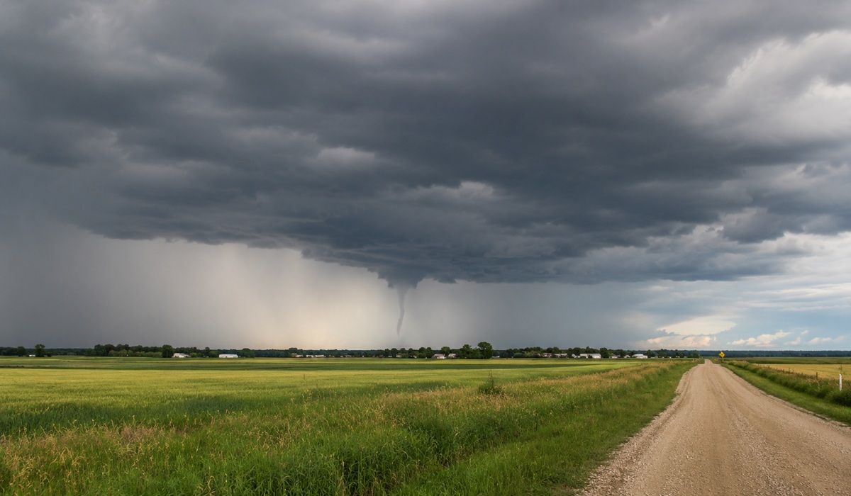
Environment Canada’s latest weather summary described Tuesday’s storms as devastating across parts of southern Manitoba, with reports of tornadoes near Ste. Anne and Otterburne, along with numerous reports of funnel clouds and possible tornadoes through the Red River Valley and western Manitoba. This followed the June 2 outbreak, when two brief tornadoes were confirmed south of Carman, adding to what has already become an active start to Manitoba’s severe weather season. The full extent of the damage from the latest storms is still being assessed, which means the final count of tornadoes, property losses, crop damage, and insured damage may take time to confirm.
The emergency alerts on phones are not accidental, and they are not overkill. They are part of a system designed to get people’s attention when a storm is capable of producing tornadoes, destructive hail, damaging winds, or flash flooding. The reason they seem to be going off more often is partly because storms are active, partly because the warning system is more aggressive, and partly because radar, storm spotters, social media video, and public reporting now catch events that may have gone undocumented decades ago.
That does not mean nothing has changed. Southern Manitoba sits in a dangerous collision zone where warm, humid air can push north while cooler, drier air drops in from the west or northwest. When those air masses meet with strong wind shear, thunderstorms can rotate, intensify quickly, and produce tornadoes, hail, and torrential rain in the same system. That is why one storm day can bring everything at once: tornado warnings, flooded streets, smashed crops, dented vehicles, and hail large enough to damage roofs and windows.
The bigger climate question is more complicated than a simple slogan. Scientists are careful about saying climate change directly causes one tornado, because tornado records are messy and detection has changed over time. But warmer air holds more moisture, and moisture is fuel for thunderstorms, heavy rainfall, flash flooding, and stronger storm environments. In plain language, Manitoba is seeing the kind of unstable, high-energy weather setup that can turn a summer afternoon into a serious emergency in minutes.
Winnipeg should not treat this as something that only happens to rural Manitoba. The last documented tornado event inside Winnipeg was July 6, 1987, when a thunderstorm produced at least two tornadoes in the city, along with strong winds and roughly 40 millimetres of rain in two and a half hours. Public Safety Canada records show there were no fatalities and no injuries, but the storm caused flash flooding and considerable property damage.
That 1987 event matters because it answers the question many Winnipeggers are now asking: can a tornado touch down in the city? Yes, it can. Winnipeg’s size, density, mature tree canopy, older neighbourhoods, power lines, underpasses, and high-traffic routes would make even a weaker tornado or violent wind event a serious public safety problem.
The danger is not just the funnel cloud. It is the chain reaction that follows. A severe storm can knock out power, flood underpasses, trap vehicles, damage homes, shut down traffic lights, overwhelm drainage, and send emergency crews across the city all at once. Add hail into the mix, and the damage spreads from homes and vehicles to crops, greenhouses, businesses, and public infrastructure.
This is why the conversation has to move beyond shock. Manitoba has always had tornado risk, including historic and deadly outbreaks, and the province is home to Canada’s only officially rated F5 tornado, the 2007 Elie tornado. What feels different now is the frequency of alerts, the visibility of storm footage, and the sense that severe weather is no longer something happening far away from Winnipeg.
The public should not panic, but it should prepare. A tornado warning means people should move indoors, get away from windows, and go to a basement or the lowest interior room available. In a city like Winnipeg, preparation also means knowing which underpasses flood, keeping phones charged during storm watches, taking alerts seriously, and understanding that a calm sky in one neighbourhood does not mean another part of the city is safe.
What is going on in Manitoba is not one thing. It is geography, climate, better detection, stronger public alerting, and repeated storm systems arriving with the right ingredients for severe weather. The result is a province where tornadoes, hail, flooding, and emergency alerts are no longer rare background events. They are becoming part of the summer reality, and Winnipeg needs to act like it.
Sources used include ECCC’s June 10 Manitoba weather summary, current Winnipeg forecast/alert page, Public Safety Canada’s disaster database, and climate/extreme-weather background from Canada’s Changing Climate Report. (kamala.cod.edu)


