
Jamaica Faces Nature’s Fury: Category 5 Hurricane Melissa Nears Landfall
- Kingston Bailey
- Breaking News
- Climate Change
- October 27, 2025
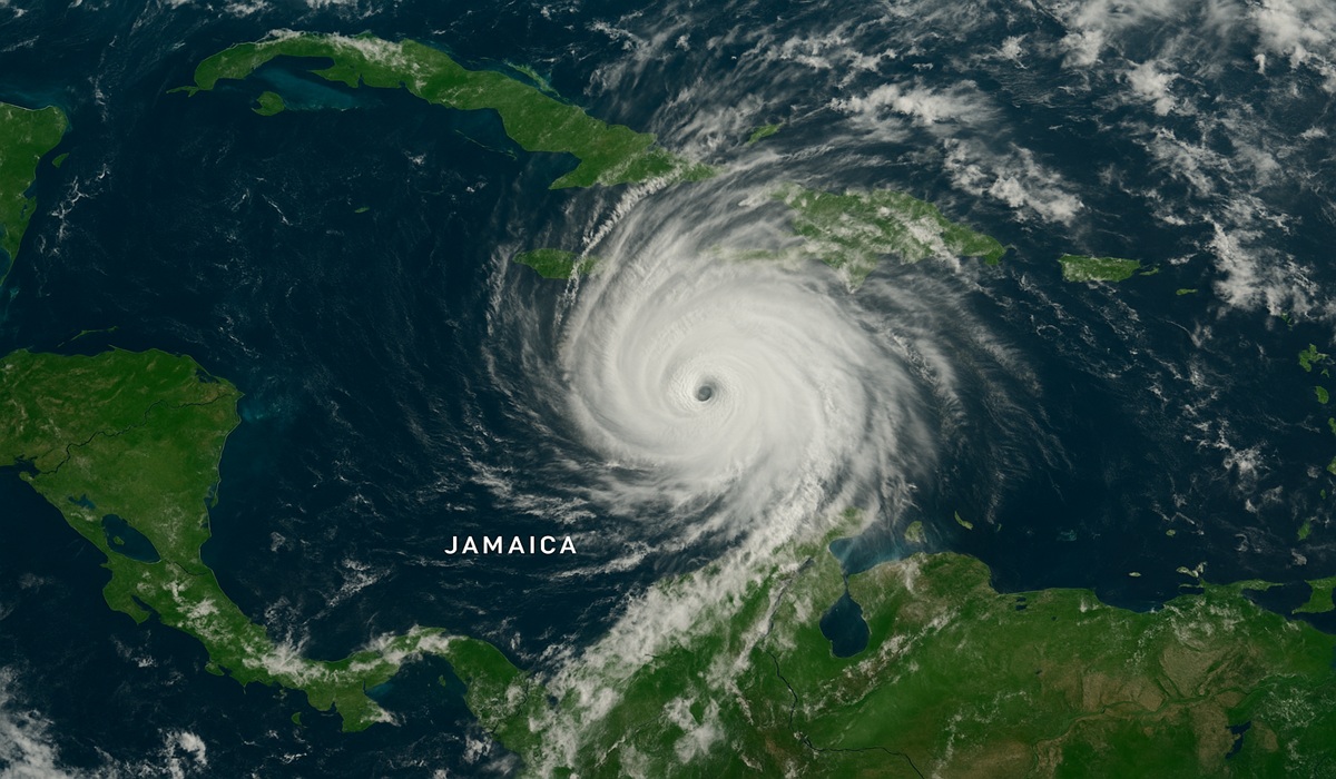
Jamaica stands in the path of the immense fury of Hurricane Melissa, which has rapidly intensified into a Category 5 hurricane as it moves into the Caribbean Sea. The storm is expected to make landfall late Monday night or early Tuesday morning local time, positioning Jamaica as ground zero for what meteorologists warn could be the most powerful hurricane the island has ever encountered.
Current forecasts indicate sustained winds in excess of 160 mph (257 km/h) and possibly reaching 175 mph, marking this as an extraordinary event in Jamaica’s hurricane history. The system is moving slowly—under 5 mph in some reports—which dramatically raises the risk of prolonged rainfall, flooding, storm surge, and landslides.
Authorities in Jamaica have initiated mass evacuations and issued mandatory orders for low-lying and coastal communities, especially around the southern coast and the capital region of Kingston. Major airports have been shut down, shelters opened, and emergency response systems activated. As of this moment, outer rain bands and tropical-storm conditions are already affecting parts of the island ahead of the hurricane’s core.
Forecast figures are bleak: Jamaica could see rainfall totals of 15 to 30 inches (380 to 760 mm), with isolated pockets receiving up to 40 inches (1,000 mm or more) of rain. Storm surge along the southern coast may rise 9 to 13 feet (2.7 to 4 m) above ground level, especially in areas where the hurricane makes landfall. In short, Jamaica is bracing for catastrophic impact as Hurricane Melissa heads directly toward it.
Given the forecast track and strength of the storm, the greatest impact is expected along Jamaica’s southern coast—the belt that includes Kingston and surrounding parishes. The island’s mountainous terrain will worsen rainfall runoff, triggering deadly landslides and flash flooding inland, while coastal areas face the dual threat of wind damage and storm surge. Hotels and resorts on the north shore have already begun lockdown procedures, but no part of the island is considered safe from the storm’s reach.
Because the storm is expected to linger or move slowly across the island, the rainfall threat is as serious as the wind. Saturated soil, runoff into valleys, and the isolated nature of rural settlements mean that even if direct landfall winds weaken, the flooding could still be devastating. The storm’s slow movement also increases the duration of violent conditions—meaning prolonged power outages, communication breakdowns, water-supply disruptions, and widespread humanitarian needs once it passes.
Jamaica has endured powerful hurricanes in the past, but none on the projected scale of Melissa. The most devastating in living memory was Hurricane Gilbert in 1988, which made a direct landfall across the island and caused hundreds of millions of dollars in damage. Crops were flattened, homes were destroyed, and dozens of people lost their lives. Gilbert remains the strongest and deadliest hurricane in Jamaica’s modern history.
Before Gilbert, Hurricane Charlie in 1951 delivered severe destruction and loss of life, prompting reforms in national disaster preparedness. The 1944 Jamaica hurricane was even more deadly, killing more than a hundred people and destroying large parts of the island’s infrastructure.
More recently, Hurricane Ivan in 2004 passed south of Jamaica but still caused massive coastal flooding, landslides, and billions in damage, proving that even near-misses can cripple the nation’s economy and housing.
In short, Jamaica’s hurricane history tells a story of resilience—but Hurricane Melissa could redefine that history entirely. With the strongest winds ever recorded so close to the island, the next few days will test not just Jamaica’s infrastructure, but the spirit and endurance of its people. As the storm bears down, all eyes remain on the Caribbean, where nature is once again reminding the world of its unstoppable force.


