
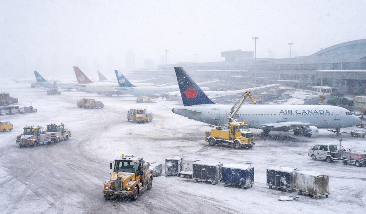
Toronto travellers have been hit with another major disruption after more than 1,055 flights were cancelled across the city’s airports in the last 72 hours due to severe weather, adding fresh strain to an already battered winter travel season. The wave of cancellations comes just weeks after a separate round of weather chaos dumped record amounts of snow across parts of the Greater Toronto Area, leaving many residents wondering the same thing. Where is all this snow coming from, and why does it feel like winter is hitting harder than usual this year?
The latest storm system brought a combination of heavy snowfall, reduced visibility, runway delays, and ground crew slowdowns, forcing airlines to cancel hundreds of departures and arrivals. While severe winter weather is nothing new in Ontario, the timing of these disruptions has been especially brutal. With people still catching up after earlier storms and post-holiday travel continuing to ripple through airline schedules, this latest round of cancellations has created a backlog that will likely take several days to fully clear.
A big part of what travellers are experiencing is the domino effect of winter operations. Snow and wind do not just delay takeoffs. They slow down de-icing, reduce the number of aircraft that can safely move on the tarmac, and limit how quickly planes can be turned around once they land. In a busy hub like Toronto, any disruption quickly spreads through the system. A cancelled flight earlier in the day can cause crews to time out, aircraft to end up in the wrong city, and passengers to miss connections that were already tight. When enough delays stack up, cancellations become the only way airlines can reset the schedule.
For many people watching this unfold, the bigger question is what is fueling such relentless storms. Meteorologists often point to a mix of classic lake-effect snow patterns and larger atmospheric shifts that pull cold Arctic air downward while drawing moisture into the system. Southern Ontario can be especially vulnerable when strong cold fronts collide with moist air, creating the kind of heavy, persistent snowfall that overwhelms normal operations. The result is winter weather that arrives fast, hits hard, and lingers long enough to throw travel plans into chaos.
At the same time, the contrast across the country is hard to ignore. While Toronto is battling heavy snow and repeated cancellations, Winnipeg and parts of Manitoba are locked in a deep freeze, with temperatures hovering near minus 40. That kind of cold is the type that shuts down more than travel. It can affect everything from vehicles and infrastructure to power systems and public safety. Yet ironically, despite the brutal cold in parts of the Prairies, Winnipeg has seen relatively little snowfall since the initial dump around Christmas, giving the city a very different type of winter. It is a reminder that weather patterns across Canada can be wildly uneven, even during the same week.
For passengers in Toronto, the immediate concern is what happens next. The short answer is that the next few days could remain unpredictable, even after the worst of the storm passes. Airlines will be working to reposition aircraft and crews, but recovery is rarely instant. Travellers should expect residual delays, tight rebooking options, and the possibility of last-minute cancellations as airlines manage a surge in passengers and limited available seats. Anyone flying should build extra time into their schedule, monitor airline alerts closely, and prepare for changes even if their flight is still listed as “on time.”
If you are currently stuck, the smartest move is to stay proactive rather than waiting at the gate for answers. Rebooking through airline apps and customer portals is often faster than lineups at the airport. If your flight was cancelled, request written confirmation and keep receipts for any reasonable expenses, such as meals and accommodations, especially if your delay extends overnight. Passengers should also check whether their credit card includes travel insurance and whether their booking qualifies for compensation or reimbursement under airline policies and federal passenger protection rules, depending on the cause of the disruption.
As for when the weather will pass, forecasts can shift quickly, but winter systems usually begin to ease once winds settle and snowfall rates drop. Even then, airports still need time to clear runways, de-ice aircraft, and restore normal traffic flow. The biggest improvements often happen in stages, with morning flights returning first, followed by a gradual normalization over the next one to three days. The key for passengers is to expect recovery to be slower than the storm itself.
Toronto’s latest wave of cancellations is another reminder that this winter is not letting up. Between sudden snow bursts, repeated storm systems, and unpredictable temperature swings, travel plans are being tested across the country. Whether it is Toronto buried under heavy snow or Winnipeg frozen under extreme cold, Canadians are seeing winter in its most disruptive form. For travellers, the best approach right now is simple but necessary. Plan for delays, leave room for changes, and assume that winter will continue calling the shots for a little while longer.


